
Burnet County · Texas
The Preserve of 1840
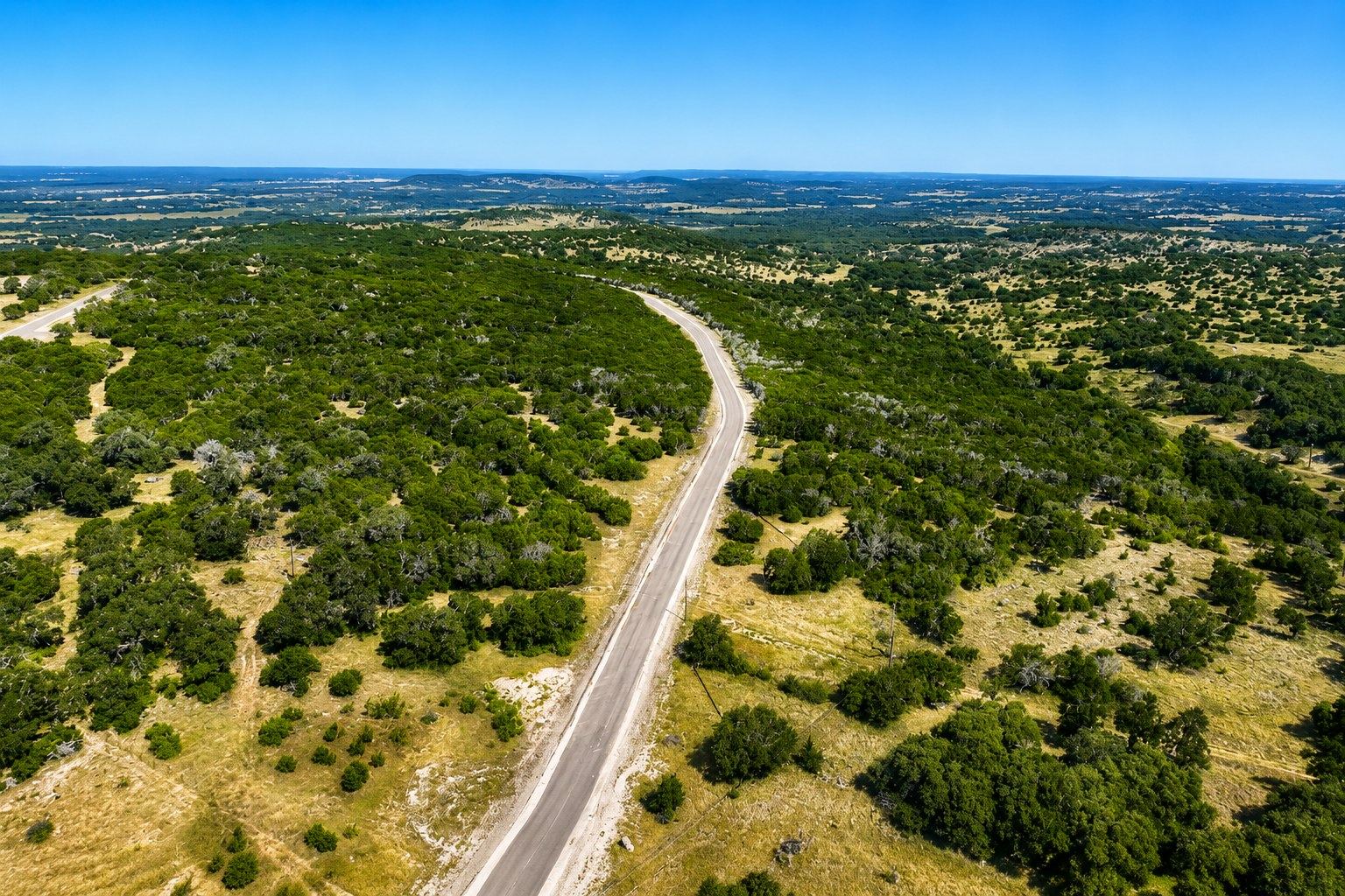
Forty gated homesites across 150 acres of Hill Country ranch land, an hour northwest of Austin. Final plat recorded November 2025. Roads built. Restrictions filed.
On the ground
Concept film — not photographs of the property
The idea of the place.
Eighty-five seconds on what forty homesites in this part of the Hill Country are meant to become — the drive in, the ridgelines, the kind of house the covenants are written to protect.
For what is actually on the ground today, keep scrolling to the recorded plat: forty lots, roads built, four wells drilled, and everything else still open pasture and oak.
Conceptual rendering. All imagery and site plans in this film are illustrative only and subject to change. The homes, vehicles, signage and landscapes shown are not photographs of The Preserve of 1840 and do not depict existing improvements.
The property
Recorded, improved, ready to build.
The Preserve of 1840 is a 150.26-acre subdivision in Burnet County, carved out of the W.R. Jennings and W.A. Star surveys and platted into forty homesites of three to five acres each.
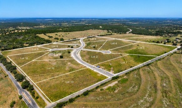
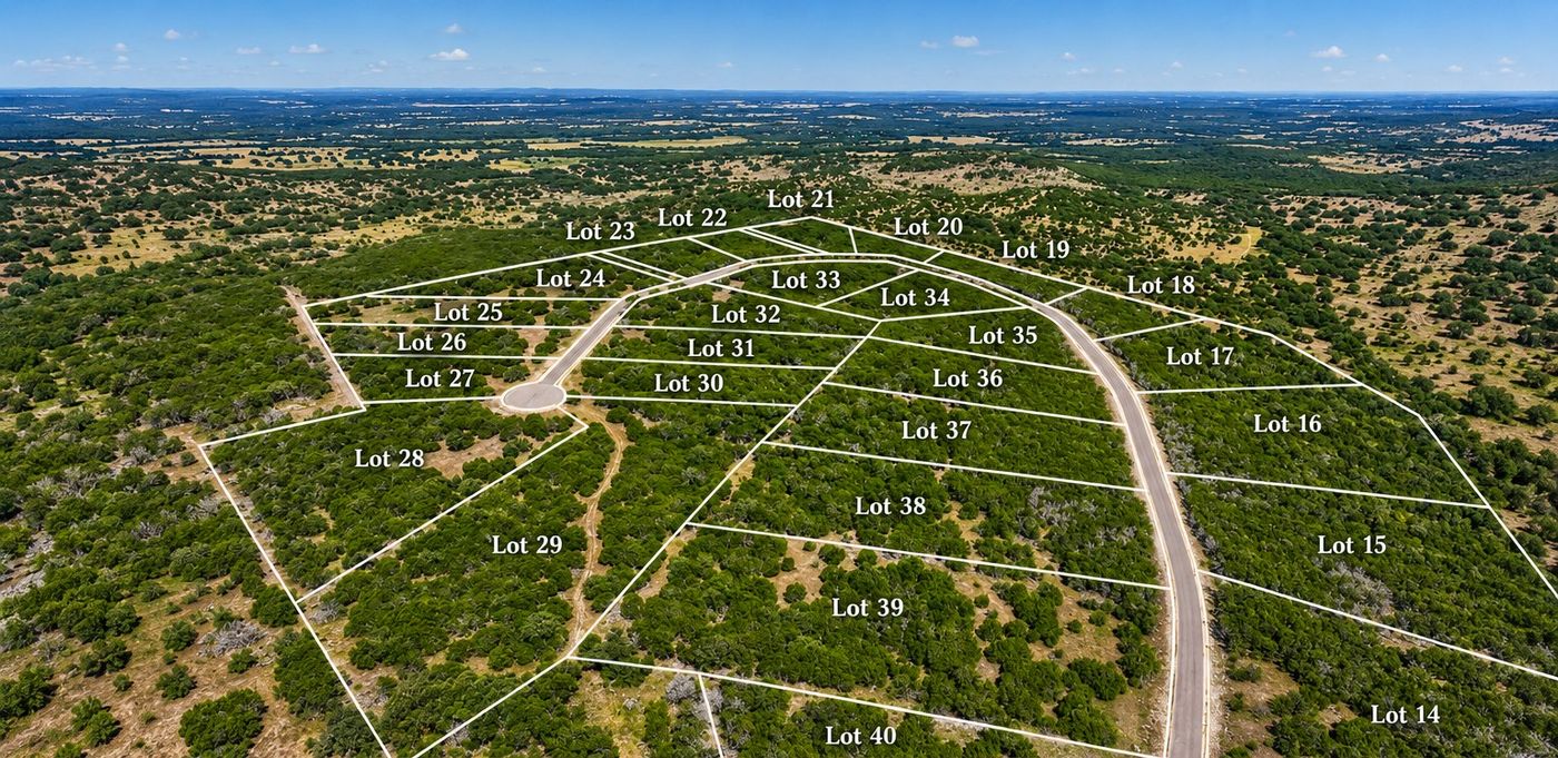
The subdivision reads as two neighbourhoods. Hayfield is the southern parcel — thirteen lots off Greystone Ranch Road, reached by Nora Grace Way and Rojo Way. Hills is the northern parcel, where twenty-seven lots wrap a long loop of Hank Williams Way and the four largest — just over five acres apiece — sit along the eastern ridge.
Four lots — 2, 4, 24 and 32 — already have a water well drilled and installed. On every other lot the buyer drills their own.
Roads are built and privately maintained. Each lot is served by its own well and on-site septic. Nothing here lies in a mapped floodplain. Covenants were recorded in November 2025 and are written to hold value: site-built homes only, 1,500 square feet minimum, masonry exteriors, fifty-foot setbacks from every lot line, and no further subdivision of any lot.
Recorded facts
Recorded plat
Choose a lot.
This is the recorded plat. Select a numbered marker for acreage and status, or jump to either section and zoom in.
Recorded plat, sheet 3 of 4 · Cuplin & Associates, Proj 241176 · Scale 1"=200' · Drag to pan, scroll to zoom
The same plat, from the air
Availability
Lot schedule
Acreages are as shown on the recorded plat. Select a row to locate that lot on the map above.
| Lot▾ | Acres▾ | Section▾ | Features | Price▾ | Per acre▾ | Status▾ |
|---|
Water
The question every buyer asks first.
On a subdivision served by private wells, supply is the risk that matters. It was studied, and then the study was independently reviewed for the groundwater district.
Four test wells were drilled across the property, all completed in the Middle Trinity Aquifer, and pumping tests were run on two of them with a third monitored for drawdown. That is one test well for roughly every 38 acres, against the one-per-100-acres the reviewing hydrologists recommend as good practice.
The Central Texas Groundwater Conservation District then asked INTERA, an independent hydrogeology firm, to review the availability study. INTERA took a deliberately more conservative view than the original study — assuming a lower-transmissivity pocket in the southeast of the tract, and stacking drawdown from neighbouring pumping at Greystone Ranch and Canyon Creek on top of the subdivision's own demand.
Even on those assumptions, roughly 75 feet of total drawdown against a starting water column of 119 to 167 feet leaves 44 feet or more of water above the bottom of the well. INTERA concluded that an adequate quantity of groundwater from the Middle Trinity appears to be available to supply the subdivision over thirty years.
Detail
The four wells already drilled sit on lots 2, 4, 24 and 32 — the lots carrying the installed-well premium. Every other buyer drills their own.
INTERA's review states that it is not a regulatory finding. Both the study and the review are available in full on request, and any buyer relying on groundwater availability should read them.
Covenants
What you can build
Drawn from the Declaration of Covenants, Conditions and Restrictions recorded 10 November 2025. The recorded document governs; this is a summary.
1,500 sq ft minimum
Exclusive of porches, garages and carports. Three stories maximum. Single-family use only.
Masonry required
One hundred percent hardiplank, stone, stucco or brick. Where hardiplank is used, at least half the exterior must be stone, stucco or brick.
50-foot setbacks
No residence or structure within fifty feet of any lot line, in addition to the setbacks shown on the plat.
10,000 sq ft impervious
Per lot, including pavement, walks and rooftops. Exceeding it requires LCRA Highland Lakes review and approval first.
No further subdivision
No lot may be divided. Adjoining lots may be consolidated into one homesite with committee approval.
Site-built only
No manufactured or mobile homes, no motor homes or house trailers kept on a lot, and no previously constructed house moved onto a lot.
Cattle and horses allowed
Within the stocking rates recommended by Texas Parks and Wildlife or the Burnet County Extension Office. No swine except a 4-H project or household use.
Shielded lighting
Light trespass is prohibited. Fixtures must be shielded so the source is not visible from other property, and non-adaptive exterior lighting is off by 11 p.m.
$500 a year
Regular assessment, payable each January, plus a one-time $1,000 initial sale fee on conveyance from the declarant.
14-day plan review
Plans go to the Architectural Control Committee. If they do not respond within fourteen days of a complete submission, the plans are deemed approved.
Six months to dry-in
Exteriors must be finished within six months of starting, and no structure may sit unfinished beyond twelve months. Landscaping within thirty days of occupancy.
Waterway buffer zones
Two buffer easements cross the property. Native vegetation is maintained by the lot owner; improvements need LCRA approval.
Diligence file
Everything we relied on.
The documents behind every figure on this page. One short form unlocks all of them.
Location
Ahead of the Austin push.
The property fronts Greystone Ranch Road off Burnet County Road 336, in the corridor between Burnet and Bertram. Highway 29 carries the growth west out of Liberty Hill and Georgetown; this is the next band of land in its path, still priced as ranch country.
Distance from the property
Straight-line distances from the plat's Point of Beginning at 30.689178, −98.154601 — converted from the recorded survey coordinate (N 10,221,090.71 / E 2,981,342.73, NAD83 Texas Central). Road distances run longer.
Site location
30.689178
−98.154601
Point of Beginning, recorded plat
Burnet County, Texas
Inquiries
Two ways to buy here.
Lots sell individually, in groups to builders on one contract, and through co-operating brokers. Every enquiry reaches a person. Call —.
Brokers & realtors
Co-op program
Co-op split of — on every closed lot, —. Client registration and protection terms are in the agreement.
Get the broker kitHomebuilders
Multi-lot takedown
Package pricing, phased takedown schedules, and the full engineering, well and plat file.
Request the builder packageIndividual buyers
Single homesite
Reserve a lot, review the recorded covenants, and walk the property with a representative.
Ask about a lot